


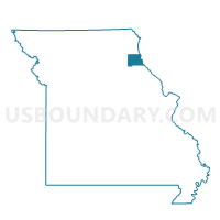
Emerson Voting District, Marion County, Missouri
About
Outline

Summary
| Unique Area Identifier | 609072 |
| Name | Emerson Voting District |
| County | Marion County |
| State | Missouri |
| Area (square miles) | 59.28 |
| Land Area (square miles) | 58.82 |
| Water Area (square miles) | 0.46 |
| % of Land Area | 99.23 |
| % of Water Area | 0.77 |
| Latitude of the Internal Point | 39.90279760 |
| Longtitude of the Internal Point | -91.70706640 |
Maps


Graphs
Select a template below for downloading or customizing gragh for Emerson Voting District, Marion County, Missouri


Neighbors
Neighoring Voting District (by Name) Neighboring Voting District on the Map
- Bethel/Tiger Fork Voting District, Shelby County, MO
- Durham Voting District, Lewis County, MO
- Maywood Voting District, Lewis County, MO
- Philadelphia Voting District, Marion County, MO
- Smileyville/Taylor Voting District, Marion County, MO
- Steffenville Voting District, Lewis County, MO
Top 10 Neighboring County Subdivision (by Population) Neighboring County Subdivision on the Map
- Union township, Lewis County, MO (1,872)
- Highland township, Lewis County, MO (1,676)
- Fabius township, Marion County, MO (1,273)
- Union township, Marion County, MO (870)
- Round Grove township, Marion County, MO (835)
- Salem township, Lewis County, MO (438)
- Tiger Fork township, Shelby County, MO (205)
Top 10 Neighboring Unified School District (by Population) Neighboring Unified School District on the Map
- Palmyra R-I School District, MO (6,736)
- Lewis County C-1 School District, MO (6,554)
- Shelby County C-1 School District, MO (2,131)
- Marion County R-II School District, MO (1,278)
Top 10 Neighboring State Legislative District Lower Chamber (by Population) Neighboring State Legislative District Lower Chamber on the Map
Top 10 Neighboring State Legislative District Upper Chamber (by Population) Neighboring State Legislative District Upper Chamber on the Map
Top 10 Neighboring 111th Congressional District (by Population) Neighboring 111th Congressional District on the Map
Top 10 Neighboring Census Tract (by Population) Neighboring Census Tract on the Map
- Census Tract 9601, Marion County, MO (4,339)
- Census Tract 9602, Marion County, MO (3,240)
- Census Tract 9703, Lewis County, MO (2,659)
- Census Tract 4501, Shelby County, MO (1,880)
Top 10 Neighboring 5-Digit ZIP Code Tabulation Area (by Population) Neighboring 5-Digit ZIP Code Tabulation Area on the Map
- 63461, MO (5,876)
- 63440, MO (1,407)
- 63454, MO (946)
- 63434, MO (687)
- 63463, MO (652)
- 63471, MO (639)
- 63438, MO (466)